Ensure efficient acquisition of marine measurement data with a suitable data management system

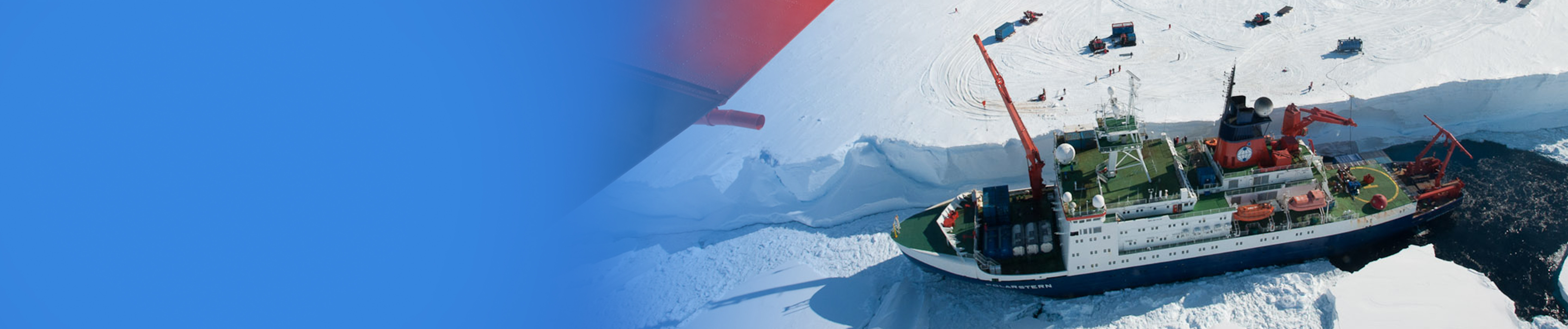
Polar regions and oceans play a vital role in the global climate system. Thus, exploring these regions is of particular importance when making decisions regarding our Earth's climate today and in the future. However, it takes scientists a lot of effort and material input to get to these regions. The frequently harsh and hostile environment puts humans and equipment under enormous stress. That makes the data collected there valuable in two respects: collecting them costs a lot of money and time and it may be very difficult or even impossible to gather these data a second time.
For this reason, it is essential that the best possible data quality is achieved at the first go and that data losses are prevented. That is why you need a reliable data management system – one that provides you with top quality data.
A measurement data management system does more than just collect and archive your measurement data
Scientists, ship owners and users in data centers know full well: marine research – and especially research shipping - imposes special requirements on a measurement data management system. With this in mind, the sustainable collection and management of precious scientific data from research projects starts much earlier than their actual safe acquisition and recording on the research platform and it doesn't end with their long-term archiving on shore: the IT system must be capable of efficiently controlling the processes way before and after the actual expedition.
Top data quality by constant monitoring
One of the important tasks is to assemble data from various origins and meaningfully correlate them to one another. The data are supplied by the sensors of the small or large devices employed, the sensors of the research vehicle used and by the scientists in the form of logged results.
By comparing these data, you can assess their individual quality straightaway. In specific circumstances, it is even possible to adjust the measurement equipment while the vessel is in transit or to repeat a measurement on the spot. For large research vehicles, it's ideal if the analysis can be carried out on the vehicle itself.
An optimum data management system would provide for various tools to track down sensor errors or failures or potential configuration errors and repair them while still on board:
- Limit value monitoring
- Plausibility functions
- Options to compare the measurement values of different sources
- Data transfer for initial analyses on shore or to a different central receiving location
When the system detects an error state, it should immediately inform you by different means, such as:
- E-mail to the system administrator
- Alarm prompt in the dashboard
- Alarm tableau providing data for error analysis
Correcting errors directly saves subsequent laborious adjustments or even data that can be deemed useless.
DSHIP - Data and Information Management for Research Vessels
DSHIP is our data management and distribution platform for research vessels that has proven successful for over 20 years. Driven by the specific demands scientific users, ship owners and data centers place on the collection and processing of measured data, it is continually advanced and safeguards sustained availability of the data on board and at associated shore-based archives.
Easy integration of any kind of measurement devices

More often than not, measurement devices are custom-made items, special devices or global novelties and are subject to frequent changes. Therefore, it is essential that the system supports your preliminary planning at the best possible rate by providing options to check the devices' master data, to add new master data or to update existing ones. Or your devices have special demands regarding the format of additionally supplied data like time or position: with a suitable measurement data management you can cover all these requirements and it will be easy for you to connect an unlimited number of devices in no time – at best you can do it at any required time and can configure them as required.
Reliable logging of all relevant measurement data

Time and again in the course of your research project there will be events you want to link to your measurement data. For this purpose, it's important that logging these events is easy. If you have the right measurement data management system, it automatically complements the event data with context data like time, position, device used or current station number so that manual input is limited to a minimum. Not only does this save you time, it also minimizes faulty input. In addition to this, you should have the option to derive parameters by combining other parameters using mathematical formulas. When done, you can display your derived values online and store them just like directly measured data.
When it comes to finding the most efficient route to the actual research area, environmental data that is continuously updated in synopsis with your planning data are a valuable help. If interactive maps and clearly designed dashboards can display this information then you can make the right decisions in near real time even before the expedition starts or while it is still underway.
Unlimited distribution and secure archiving of your measurement data

You want to make your data available and share them in an uncomplicated manner. No matter whether you want to send your data directly to any kind of device or forward them by e-mail, the best measurement data management system generates suitable telegrams and sends emails automatically for you using current sensor data, e.g. for online quality checks.
Integrated interfaces offer ample possibilities to get the best out of your data. The web-based GUI makes it easy to configure and save data exports. Alternatively, you can compress your data in an archive package for transfer to an external storage medium. There also are many other interfaces, such as TCP/IP, Modbus or UDP, that give you ample scope for your own requirements.
Your optimum measurement data management system also makes sure your data are at all times kept in a safe place. For this purpose, they are continuously stored in a central database. If you want to preclude data losses and ensure fail safety, you should mirror the data to a backup server. The backup runs your system reliably enough that no administrative intervention is required at runtime.
Dashboards just the way you want them

Presumably, you will have your own, special demands on how parameters are visualized. Your professional measurement data management system should therefore provide a flexible display framework to present any of the parameters available in the system online. You can define the display just as you need it. Or you can use pre-defined displays, e.g. for navigation, winch or weather data.
Archiving across mission limits

Looking at single expeditions, several journeys of individual research vehicles or a single research station doesn't suffice to retrieve the hidden data treasure. That is why the data should safely be transferred to a comprehensive long-term archive where they are correlated in terms of space and time. There, scientists can clearly identify all the data they are interested in and download them for analysis purposes.
A long-term archive will develop its full potential when it collects the data of different research projects and missions, enables data analyses across various missions and provides standardized interfaces for data access even by external analysis and evaluation tools. Then, the archive can be the starting point for the analysis and evaluation of maritime measurement data and provide the database for new discoveries. They are the fuel that nurtures the development of new ideas and creates the basis for vital decisions on our future.
Ensure top quality of your data with this data management system
DSHIP, our information management system for scientific geodata, is a powerful platform that reliably takes care of managing, distributing and archiving scientific data for you. Many research facilities have been employing DSHIP successfully for many years.